Lower Reach and Estuary
-
A large pool below a section of basalt outcrop has a soft sediment bottom and is deep enough to be used as a swimming hole by neighborhood kids. A sediment bar lies across the stream near its upstream end. Exiting the pool, the stream flows through a channel choked by tall elephant grass (Pennisetum purpureum) against a high and quite steep left bank separating the stream from Puohala. The right bank descends down to the Bay View Golf Course. Kawa stream makes a broad turn to the east, where it is confined within a man-made, mostly unlined channel (Photo 8) through the golf course to a swamp forest of red (or American) mangrove (Rhizophora mangle) along the south wall of Waikalua Loko (fishpond). This segment of the stream crosses a floodplain shared with Kane`ohe Stream.
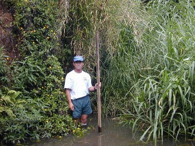
- Photo 8.
- Kawa Stream just above the transition to an estuary below Station 005. Note the steep soil bank behind Paul (DOH) and heavy growth of emergent vegetation in the stream bed.
At the present time Kawa Stream does not enter Waikalua-Loko Fishpond directly, but flows parallel to and outside the south fishpond wall (here mostly an earthen berm) discharging into Kane`ohe Bay through Waikalua fishpond (a remnant fishpond east of Waikalua-Loko). Kane`ohe Stream enters the bay along the north side of Waikalua-Loko. Maps from the mid-1800's (reproduced in Cultural Surveys Hawaii, 1989) show both Kawa Stream and various auwai which drained the taro lo`i located between the lower courses of Kane`ohe and Kawa Streams once fed directly into Waikalua-Loko fishpond.1, 2 The estuarine segment of Kawa Stream extends from about the eastern edge of the Bay View Golf Course to the stream mouth, a distance of about 700 m. The channel is straight and varies in width from about 7 to 9 m. Water depths range from about 1 to 1.5 m. This channel was dredged to its present width around 1958, when wetlands here were reclaimed for building the Kaneohe WWTP. It was again dredged in 1965 to remove accumulated sediment (VTN Pacific, 1977). Fishes noted as present here include aholehole (Kuhlia sandwicensis), tilapia (Oreochromis mossambicus), juvenile barracuda (Sphyraena barracuda), manini (Acanthurus triostegus), and jack (Caranx sp.), as well as several native gobies and blennies (Eleotris sandwicensis, Stenogobius hawaiiensis, & Awaous guamensis)4. Invertebrates noted were oysters, barnacles (Balanus sp.), grapsid crab (Metopograpsus thukuhar), blue-pincher crab (Thalamita sp.)3 and `opae oeha`a (Macrobrachium grandimanus)4. One is likely to see red-eared slider (Trachemys scripta elegans) turtles in the lower and estuarine reaches of Kawa Stream.
Other Stream Branches
-
In addition to the central branch of Kawa Stream and the several tributaries feeding into the central branch as discussed above, there are 4 or 5 small tributaries that drain into the Kawa Stream estuary. These are intermittent streams mostly similar in character to the middle east branch in that swales in the hills behind Pikoiloa drain during storms to culvert inlets at the forest/suburban boundary. These freshet flows are then diverted through pipe culverts that discharge (with one exception) on the makai side of Kaneohe Bay Drive. The exception is the open swale forming the back boundary of the Nohonani Place Development between Namoku Street and Kaneohe Bay Drive at Keana Road.
Some of these small streams drain into grass-dominated wetlands that are remnants of formerly more extensive lowland marshes now surrounded by Bay View Golf Course. Drainages further east are all intermittent. From about the Kokokahi YWCA, drainage flows enter a narrow mangrove belt along the southern shore of Kane`ohe Bay.